


le valtin

PatriceCocuaud
User
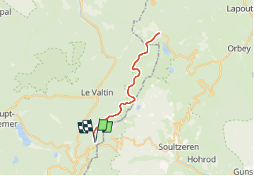

Length
24 km

Max alt
1237 m

Uphill gradient
367 m
Km-Effort
29 km

Min alt
1136 m

Downhill gradient
368 m
Boucle
Yes
Creation date :
2023-01-29 13:13:11.564
Updated on :
2023-01-29 15:10:05.412
1h44
Difficulty : Medium

FREE GPS app for hiking
 SityTrail
IGN / Geographical institutes
SityTrail Plus
The world is yours!
About
Trail Cross-country skiing of 24 km to be discovered at Grand Est, Vosges, Le Valtin. This trail is proposed by PatriceCocuaud.
Positioning
Country:
France
Region :
Grand Est
Department/Province :
Vosges
Municipality :
Le Valtin
Location:
Unknown
Start:(Dec)
Start:(UTM)
352664 ; 5325506 (32U) N.
Comments